The physical aspect of walkability: a model for evaluating the effect of climate and topography on pedestrian route preferences

2024-ongoing

Funding agency: Technion Sustainability Frontier

Researchers: Or Aleksandrowicz, Sagi Dalyot, Gil Revivo

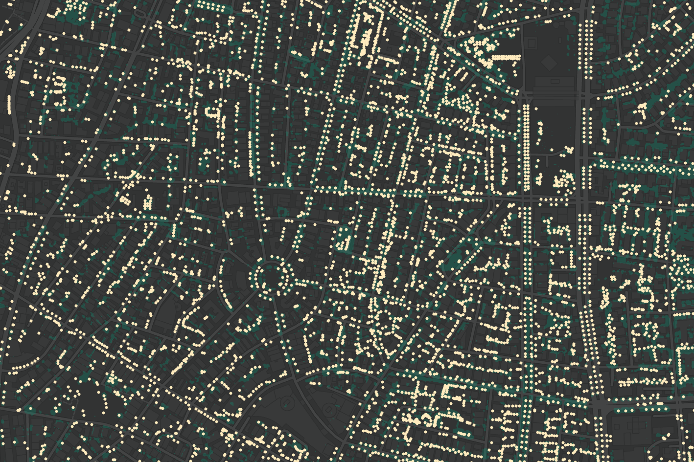
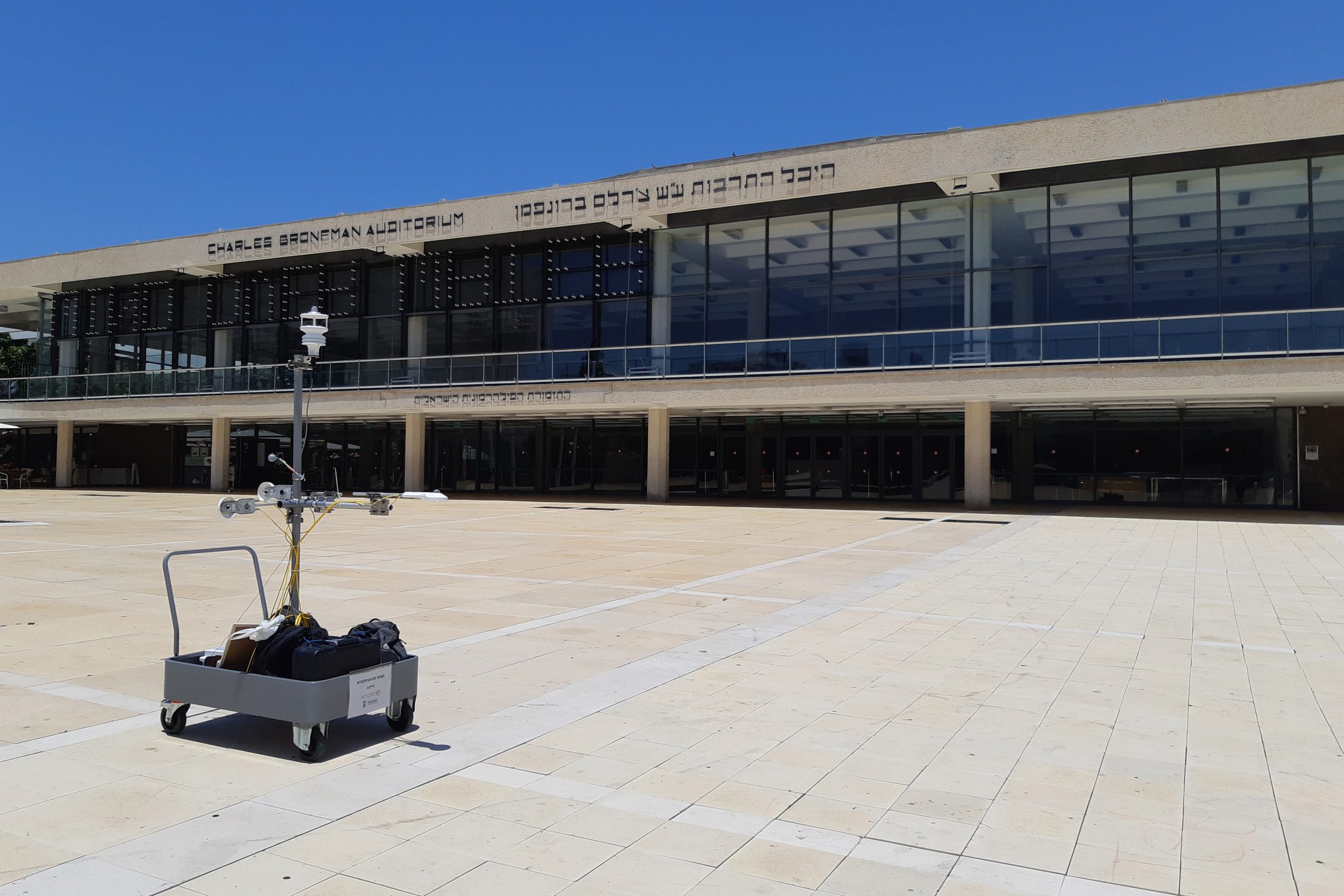
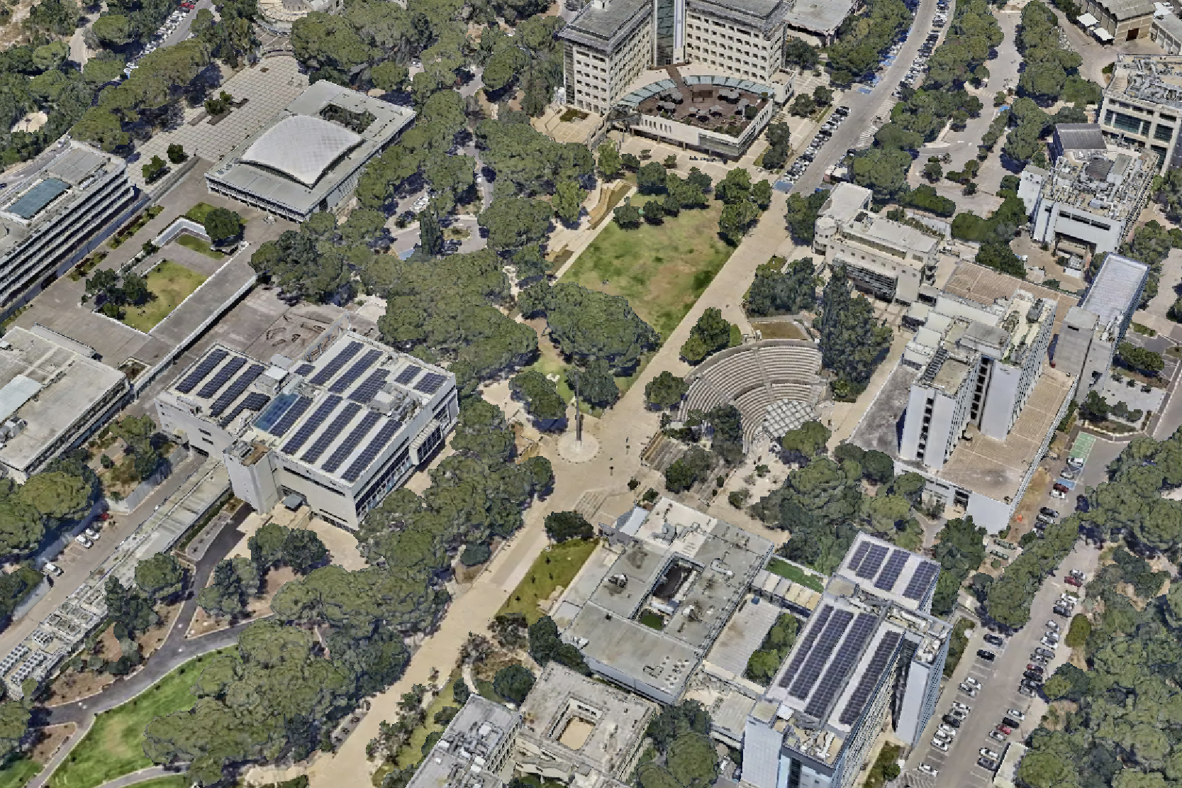
This study attempts to quantify the negative effect of solar exposure and steep topography on walking preferences and to develop a prediction model that could be used to estimate the increase in pedestrian traffic as a result of improvements in shade provision. In this study, we aim to conduct a systematic monitoring of pedestrian flows at the Technion campus during the hot season. Monitoring will be done using mixed data collection methods: walking trajectories from GPS observations from a smartphone app installed by volunteers and anonymized pedestrian entry records from the Technion’s main gates.

The pedestrian data will be supplemented with GIS data used for shade mapping of all pedestrian routes on the campus, highlighting poorly shaded paths, and topographic mapping of the campus, quantifying the steepness level of pedestrian routes. By combining the pedestrian and physical environmental data, we will be able to identify daily and seasonal trends of pedestrian flow, map the main pedestrian routes around the campus, and relate them to shade provision and topographic features.

The study is expected to provide an evidence-based analysis of pedestrian behaviour on the Technion campus while pointing to possible impediments to increasing walking within the campus and possibly also to it. At the same time, the study will serve as a basis for developing a model that will quantify the effect of lack of shade and steep topography on pedestrian flows. The opportunity to use the Technion campus as a living lab for exploring the study’s underlying assumptions will support the development of a comprehensive model based on more extensive datasets.

אשדוד 1961 הלגה קלר ארכיון הסרטים הישראלי

The climates we have built: Historicizing urban climates as products of urban planning

2023-ongoing

Funding agency: Israel Science Foundation

Research leader: Or Aleksandrowicz

Researcher: Omri Shafer-Raviv

Urban overheating is becoming a major global concern in light of climate change; yet ongoing, consistent integration of climatic considerations into everyday urban planning and design is still an accidental rarity. This discrepancy is nothing new to modern planning, indicating a persistent, fundamental failure that unless thoroughly examined in retrospect is bound to replicate itself. Nevertheless, systematic historical evidence on climatic considerations in urban planning and their impact on urban climates is still virtually non-existent.

The main objective of the project is to provide an unprecedentedly broad and holistic historical account of the interdependence of modern planning of urban settlements, scientific knowledge, and urban climates. It will ask in what sense certain historical urban configurations of the last century were more adapted to climate than others, and what impact scientists and planners had on the climates of these urban environments. Since urban climates are evaluated using quantitative climatic indicators, we cannot overlook them if we want to write histories that genuinely make sense of the climates of cities. Therefore, the project suggests an innovative way of writing histories of urban climates by integrating quantitative and qualitative research methodologies.

The project will trace the history of urban planning concepts and ideas employed in a group of modern metropolitan areas for a period of a century, offer high-resolution quantitative analyses of historical urban climates of the same locations and period, explore the historical development of the science of urban climatology during the same period, and map the changing attitudes towards climatic planning and design among public and professional circles. In the end, it will offer new insights into the historical circumstances and contexts that promoted or impeded the realization of modern urban planning and design schemes consisting of significant heat mitigation qualities.

Tree planting potential

Development of a novel method for calculating and high-resolution mapping of urban tree planting potential

2023-ongoing

Funding agency: Israel Ministry of Innovation, Science and Technology

Research leader: Or Aleksandrowicz

Researchers: Sivan Sharabi, Daniel Rosenberg

Planting shade-providing trees in streets and open spaces is known to reduce urban heat and outdoor heat stress, making urban forest densification one of the key measures that is currently being adopted in almost any climate adaptation strategy around the world. Yet, despite the acknowledged climatic significance of urban tree planting, we still lack comprehensive and evidence-based methodology for accurately calculating tree planting potential in cities. This, in turn, impedes efficient and effective allocation of resources to the promotion of urban forest densification. The main objective of the study is, therefore, to develop a novel comprehensive method that will allow for high-resolution, quantitative evaluation of urban tree planting potential based on regularly produced physical mapping of cities. We will develop this method based on the Survey of Israel’s existing physical mapping databases of more than 30 of the most populous Israeli cities.

The outcomes of the study will consist of tree-related interactive maps of the analysed cities and a digital platform that allows users to explore different urban planting scenarios based on the climatic qualities of existing trees and buildings, physical constraints, social equity considerations, and a novel street tree density benchmarking system that we will develop in the study. The platform will enable users to calculate the precise quantities and costs of additional tree planting and to mark prospective planting locations. We expect that the study’s outcomes to significantly improve the capacity to accurately estimate urban forest densification magnitude and costs at the national and municipal levels in Israel and abroad.

Securing climatic accessibility to public transport? A data-driven approach to urban shading operations

2023-2024

Funding agency: Environment and Sustainability Research Center, The Open University of Israel

Researchers: Or Aleksandrowicz, Daniel Rosenberg, David Pearlmutter

Accessible and readily available public transport is perceived today as an essential component in securing urban quality of life and as one of the central goals of any urban sustainability vision. However, accessibility to public transport is often presented as depending mainly on the walking distance between users’ starting points and transportation stops and the quality of the physical infrastructure dedicated to walking. Surprisingly, this approach ignores the need to secure thermal comfort in the pedestrian access routes to the transportation stops. This study was intended to provide an initial response to this gap by developing a method for prioritising improvements to the climatic accessibility of transportation stops. The prioritisation indices we developed are based on quantifying the gap between the intensity of stop use and the degree of solar exposure of the footpaths leading to the stops. The study focused on three major cities in Israel: Tel Aviv-Yafo, Haifa and Be’er Sheva, as well as the town of Netivot.

 The study included the analysis and cross-referencing of two main datasets: a dataset of travel ticket validation in public transport that the Ministry of Transport shares with the public and shade maps of streets and statistical zones of the four cities analysed in this study. From the ticket validation dataset, it was possible to learn about daily and seasonal trends in public transport travel in each city, as well as to calculate the daytime average passenger flow during the hot season for each transportation stop. The shade maps allowed us to calculate the level of hot season shading in the routes leading to each stop or in the streets within specific zones. Using these two datasets, we calculated a new index, the Shading Priority Index, which quantified the importance of adding street shading as a product of the average shading situation and number of public transport passengers during the day.

 In this study, we present two shading prioritisation indices: one, at the resolution of a single transportation stop, is based on an analysis of the shading situation in all the pedestrian routes leading to each stop and the number of passengers boarding public transport from that stop; The other, at the much lower resolution of a statistical zone, is based on an analysis of the average shading and passenger quantities at all stops in a particular statistical zone. Of the two, the shading prioritisation index at stops is more focused, rich, and geographically detailed, but its calculation requires a more complex procedure. An analysis of the mapping results of the shading prioritisation index at stops and statistical zones indicates that using the more complex index for calculation (shading prioritisation at stops) yields more spatially accurate results, including highlighting secondary activity centres that do not receive prominence in the statistical zones analysis. On the other hand, each of the two indices leads to the conclusion that in each city we analysed, shading operations should be focused on areas bordering almost all the urban train stations, and in this respect, it is also possible to rely on the shading priority index in statistical zones to define areas of top urban priority for shading. 

 The calculation of shading prioritisation indices in the four cities we examined in the study made it possible to reveal significant differences between the cities, both in passenger quantities from different transportation stops and in the shading conditions in the routes leading to them, and to identify key weak points of climatic accessibility to transportation stops in each city. These differences emphasise the importance of individual mapping of shading conditions and passenger quantities in each city before deciding on shading actions in urban spaces. The mapping produced during the study makes it possible to determine that the method we present here can be implemented relatively easily and on a relatively large scale in all cities in Israel for clear prioritisation of streets and areas where shading operations are required. The widespread application of this method in other cities may also enable decision-makers and planners to identify recurring vulnerabilities in climatic accessibility to public transport throughout the country and conduct a comparative examination of the level of climatic accessibility to public transport between different cities. Cross-referencing with spatial socioeconomic indicators, the metrics developed in this study may also help expose gaps in climatic accessibility to public transport that particularly affect the access of disadvantaged populations to this public resource.

Deciphering visual comfort in buildings through analyzing large datasets of real-world adjustable blind operation

2022-2024

Funding agency: Technion Data Science Initiative

Research leaders: Or Aleksandrowicz, Avigdor Gal

Researchers: Daniel Rosenberg, Uriel Cohen, Shaked Fried, Lior Motola, Ariel Novominsky, Menachem Brief

The aim of the research project was to use large-scale user window blind-control datasets to better understand and predict occupants’ visual comfort preferences and their possible effect on building energy consumption. We have been able to systematically clean and process a raw dataset of 339 blind controllers installed on the three upper floors of an office building in Tel Aviv to infer the automated blind operation schedules on different building facades. The automated operation of a blind depends on the solar orientation of the façade it is installed in, following a solar calculator that considers the date, time, orientation, and geographic location of the building. Based on the dataset analysis, we were able to create user intervention “heat maps” showing the frequency of user override of the automated blind operation at different time scales: annual, monthly, and daily. These graphic presentations of the data thus enabled us to better trace similarities and differences in user behaviour and to define different “user types” who show recurring patterns of intervention.

Finding the first modernist building in Tel Aviv: A data science approach

2022-ongoing

Funding agency: Center for Humanities and AI

Research leaders: Or Aleksandrowicz, Maoz Azaryahu

Researchers: Anat Goldman, Daniel Rosenberg, Yoav Orion, Ido Baum

The project aimed to produce rigorous evidence about the emergence and adoption of architectural modernism in residential building design in Tel Aviv through systematic examination of all the buildings (about 7,000 in number) that were constructed in the city between 1921 and 1940. This evidence was used for understanding the historical context and motivations behind the introduction and adoption of the modernist architectural idiom in Tel Aviv and for the identification of individual architects who played a key role in that process. Based on these findings, we also sought to evaluate to what extent the adoption of the architectural modernist idiom in Tel Aviv was motivated by ethical and ideological reasons, or whether other factors were involved in this process.

Kikayon: a computational tool for interactive evaluation of street shading

2021

Funding agency: Israel100 Initiative

Research leader: Or Aleksandrowicz

Developer: Ezra Ozery


To date, there is a lack of orderly and data-based methods for quantifying, evaluating, and benchmarking street-level outdoor shade in streets and urban public spaces. The lack of such methods impedes the effective design of walkable and liveable outdoors in locations where shading is essential for significantly mitigating outdoor heat stress. To address this shortcoming, we have developed Kikayon, a relatively simple parametric tool that allows planners and designers to easily compare the effect of design alternatives on outdoor shade provision based on building geometry and tree canopy morphologies while taking into account the variance of exposure to solar radiation at different times. The tool calculates several shade and tree indices, some we have originally developed, for each street design, giving users quick and straightforward feedback and enabling them to quantitatively compare design alternatives. Our tool is implemented as a Grasshopper code that harnesses several components of the Ladybug Tools suite.

You can download the code from: Kikayon: a computational tool for interactive evaluation of street shading.

See also: Or Aleksandrowicz and Ezra Ozery, A Parametric Tool for Outdoor Shade Design: Harnessing Quantitative Indices and Visual Feedback for Effective and Efficient Climatic Design of Streets, Proceedings of CAAD Futures 2023: Computer-Aided Architectural Design. INTERCONNECTIONS: Co-computing Beyond Boundaries, 2023. https://link.springer.com/chapter/10.1007/978-3-031-37189-9_20.


Development of an integral microclimatic analysis tool for combating urban heating

2019-2023

Funding agency: Israel Science Foundation

Primary researcher: David Pearlmutter

Project supervisor: Or Aleksandrowicz

Project researchers: Michelle Clark Levenson, Morel Weisthal, Tanya Saroglou, Ayelet Eli-Av, Valeria Aynbinder

Research assistants: Wolfgang Motzafi-Haller, Yaakov Florentin, Tzur Blank, Yosef Mor

The research project set out to develop an integral microclimatic analysis tool that would support planning decisions related to urban heat mitigation and adaptation. We found the existing common computational tools for analysing the effects of urban heat on pedestrian thermal comfort to be too complex and resource-intensive to provide planners and designers with city-scale mapping of the variance in urban heat. Acknowledging that the main challenge lies in the complexity of calculating thermal comfort according to common comfort indices, the project was focused on addressing this gap by attempting to identify climatic variables that are relatively easy to calculate while providing a good indication of thermal comfort levels. For this, we conducted two monitoring campaigns of urban summer and autumn conditions in two Israeli cities (Tel Aviv-Yafo and Kfar Saba), and their results highlighted the critical effect solar exposure has on significantly increasing heat stress during daytime hours. Moreover, by monitoring pedestrians’ choice of walking routes in shaded and unshaded conditions, we were able to show that pedestrians tend to prefer walking in the shade during summer, thus further highlighting shade provision as the single most important climatic factor planning and design professionals should address.

The exceptional significance of shade provision in climatic planning enabled us to argue that mapping shade conditions across an entire city can be a valuable tool that could bridge the gap between the science of urban climatology and the planning and design professions in geographic locations where urban heat is a major climatic challenge. Essentially, shade is a direct outcome of planning and design decisions and mainly depends on the sheer physicality of urban features. Because of that, the calculation of outdoor shade is relatively less complex than the calculation of urban thermodynamics. Nevertheless, when calculating shade for an entire city, current tools are still relatively slow and cumbersome. The Urban Shade Assets Mapper, the tool we have developed in this project, is expected to streamline and facilitate the production of shade maps based on common and readily available geographic datasets.

Final scientific report

MAQOM: A new digital platform for geotagging and accessing large digital photo collections

2022-ongoing

Funding agencies (POC): National Library of Israel and Yad Hanadiv

Research leader: Or Aleksandrowicz

Developers: Daniel Rosenberg, Ivan Vasilyev

Research assistants: Elad Horn, Yoav Orion

The growing quantities of digitized photographs create new opportunities to overcome the inherent difficulties of collecting visual place-related data from a multiplicity of sources, precisely because digitization can offer uniform platforms for data storage, categorization, extraction, and presentation. Nevertheless, as large collections of digitized historical photographs have been created and made available via the internet, it became evident that there are two major inherent problems with the way such data is currently indexed, stored, and made accessible.

The first challenge emanates from the need to systematically add precise geographic reference to each digitized item to efficiently retrieve it based on its geographic location. When processing large datasets this task can become daunting, if not unfeasible by relying only on the human resources of the institutions that manage collections of digital data. Secondly, the hurdles of place-related data extraction are further exacerbated because verbal descriptions of locational data are frequently inaccurate or incomplete. This can be attributed to the inaccurate or incomplete nature of verbal descriptions of source materials assigned to the items by their original creators but can also reflect the more basic limitations resulting from the act of verbally describing places. Even when we know the exact geographic location embedded in a digitized item the words we use to make sense of it may exclude important pieces of information that are essential for conveying its cultural significance as a place.

To overcome these two challenges, we have developed an online indexing and presentation platform (named MAQOM) that consists of a map-based search interface capable of simultaneously presenting and efficiently browsing through a variety of media sources, including digitized photographs. The users retrieve the place-related items by clicking on the interactive map and can filter the presented items via free-text search or by actively changing the geographic extents or the temporal range of the presented search results. To overcome the inherent practical limitations of large-scale georeferencing of digitized items, we suggest exploiting the power of crowdsourcing for collecting geographic and verbal place-related input from users from outside the institutions managing the photo collections. While this approach is more prone to errors than institutional indexing methods, open user feedback is expected to correct many of these errors more easily than keeping indexing behind the closed walls of institutional authority, which is always based on limited human resources and limited expertise when compared to the public’s participation in open data collection efforts.

See:

Or Aleksandrowicz, Daniel Rosenberg, Ivan Vasileyev, Elad Horn and Yoav Orion, A new digital platform for overcoming current limitations in Geotagging and accessing large digital photo collections, Digital Humanities and Social Sciences (DHSS) in Israel conference, Tel Aviv, 21.5.2024.

A Hebrew textual corpus on construction, planning, and architecture

2022-2024

Funding agency: Israel Innovation Authority

Research leader: Or Aleksandrowicz

Project supervisors: Daniel Rosenberg, Omri Shafer-Raviv

Project advisors: Noam Ordan, Nick Howell

Project assistants: Dina El Qasem, Hodaya Saada, Mai Sabbah, Sherry-Atara Khasdan, Naama Koren, Shiran-Ester Shnaiderman

The construction industry is one of the main economic sectors in Israel and it is expected to maintain its central position in the coming decades in light of the country’s rapid population growth rate. Unlike many developed countries, where the rate of new construction is slow due to low rates of population growth, in Israel, the built-up area doubles every 25 years. The creation of a textual corpus in Hebrew on construction, planning, and architecture is expected to facilitate and expedite the development of NLP-based tools for application and assimilation in technological fields related to the construction industry.

The corpus consists of Hebrew documents from a wide variety of contemporary and historical sources, including legislative decrees, regulatory guidelines, research reports, academic studies, and professional journals. In the development of the corpus, we are using digitally born as well as scanned printed publications, which go through a process of optical character recognition (OCR), cleaning, and parsing. Parsing was performed using the Trankit Python Toolkit.

The corpus holds 22,382,594 words in 1218 documents.

The corpus is available for all types of uses for NLP research and development according to the CC BY 4.0 license (Attribution 4.0 International).

We wish to thank Vicky Davydov, Lena Avrahami and Shai Zack from the Library of the Faculty of Architecture and Town Planning (Technion), as well as Moti Yeger, Director of the Technion’s Central Library, and Prof. Rafael Sacks, Head of the National Building Research Institute, for the help they have been providing for the project since its inception.

Cite: Aleksandrowicz, O., Rosenberg, D., Shafer-Raviv, O., Ordan, N. (2024). Hebrew textual corpus on construction, planning, and architecture. GitHUB. https://github.com/bdar-lab/heb_architecture_corpus.